

Virtual Field Trip to Spawn Creek
Normally, in our in-person workshops, we like to take participants in the field to help you learn how to read riverscapes. The focus of reading riverscapes on these field trips is two-fold:
- Identifying valley bottoms
- Recognizing what structural forcing looks like
While there is no good substitute for tromping around in the water and mud and experiencing this for yourself, this page attempts to reproduce as much of that experience as we can virtually for you in Spawn Creek.
Topic Covered in Virtual Workshop
In the 2020 Virtual Workshop, we present this topic in Module 3 C (Valley Bottom Mapping & Virtual Field Trip) and Module 3 D (Recognizing Structural Forcing in Riverscapes).
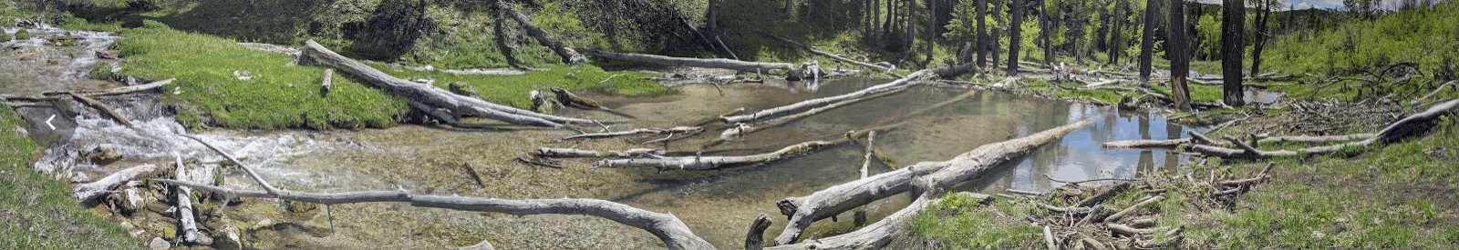
Spawn Creek Field Tour
Explore around on the map for the virtual field tour below. The red line is the route we take on the guided field tour up Spawn Creek. The yellow line is the route for the self-guided tour back down Spawn Creek.
View the map here.
Guided Virtual Tour
In this 70 minute video, you are invited to walk up Spawn Creek and read the riverscape (for roughly a 1.5 mile with lots of tangents and stops). A six minute intro gets you oriented (watch intro only here), and then the rest is Joe explaining all the same stuff he does in the real field trip as he sees it. Unlike the real field trip, where when you’ve had enough you can just hang back and wander around on your own, with this one you can fast forward if you get bored.
Intro to Guided Tour
The Actual Tour
Download the KMZ .
Self-Guided Tour
In this video, you are invited to walk down Spawn Creek (for roughly a mile and 22 minutes) and make observations about structural forcing. A four minute intro gets you oriented (watch intro only here), and then the rest is just you and the sights and sounds of Spawn Creek.
Intro to Self-Guided Tour
The Actual Tour
That’s right, there is no narration.
Download the KMZ .
Take the Survey
Tally up your counts as you watch the video and take the survey.
Take Spawn Creek Virtual Self-Guided Field Trip Survey
More to Explore
Want to keep exploring? There are albums and videos below for both Spawn Creek and its parent Temple Fork watershed you might find fun.
Spawn Creek
The video below shows a drone flight down Spawn Creek:
Part way through the guided tour, we turn up an un-named tributary and see neat examples of fossilized beaver dams (i.e. travertine). The tweet below invited people to guess how many dams are in the drone photo.
Middle of Spawn Creek and unnamed tributary with a bunch of "fossilized" travertine beaver dams (look like bedrock steps in valley bottom, but they're actually relic beaver dams that limestone rich waters precipitated) pic.twitter.com/plSokfGzG6
— Joe Wheaton (@fluvialwheaton) June 1, 2020
Above album (or full version)
Temple Fork
Spawn Creek is a tributary to Temple Fork. The album below show a bunch of video, ground shots and drone imagery from a walk up Temple Fork.
 ]
Above album (or full version)
]
Above album (or full version)
Failure?
Too often, we tend to think of structures failing as a bad thing. With natural beaver dams and wood jams, these are transient features on the landscape. Beaver dams come and go all the time, and with that we get dynamic, diverse habitat. If all beaver dams fail, and are not replaced or repaired by further beaver dam activity, that can be a cause for concern. However, a handful of beaver dams blew out in 2020, and the results are not at all bad! This tweet below happens to highlight one blow out that was actually what we used to illusrate structural forcing in Chapter 2 of the design manual (figure 2.4).
So, this was cool... the beaver dams we used as an example of principle 2 of riverscape health (structurally-forced pathway to complexity in #lowtechPBR manual: https://t.co/asPJ68JmtF) finally blew out from spring runoff! But despite mourning the loss, its MORE complicated... pic.twitter.com/n7fOlpj5T4
— Joe Wheaton (@fluvialwheaton) June 1, 2020
In the video below, I take you on an aerial tour of some recent beaver dam blow-outs, which reveal the anatomy of a beaver dam.
 Take me to Free LTPBR Workshop Modules and Self-Paced Resources