

Intro to Pumpkin Creek
Our Thursday (August 11, 2022) field trip and construction portion of the workshop will be on Pumpkin Creek.
Why are we working in Pumpkin Creek?
The Bureau of Land Management (BLM) Montana/Dakotas is seeking to improve riverscape health across the lands it manages using low-tech, process-based restoration (LTPBR) methods. Eventually, each of the field offices will identify locations for, and implement LTPBR projects on riverscapes throughout the management area. As part of this effort, the Miles City field office is conducting a pilot project with assistance from Utah State University and the Riverscapes Consortium on a section of Pumpkin Creek.
Pumpkin Creek is a first order tributary of the Tongue River located approximately 11 miles south of Miles City, Montana. It is a perennial prairie stream, located entirely within the Northwestern Great Plains ecoregion (level 3 EPA Ecoregions). This region is characterized by erratic precipitation. Stream base flows are therefore relatively low, and peak flows are driven by spring rains and are highly variable. Like much of the region, the valley bottom of Pumpkin Creek was extensively grazed by cattle, resulting in a reduction in riparian vegetation cover. Due to this reduction, there is currently almost no large wood in the channel. Beaver dams are limited in the watershed as a result of historic extirpation and a lack of current resources to support them. Without these structural elements, the channel is greatly simplified, and in most locations consists of a deeply incised single-threaded channel lacking geomorphic diversity.
Pumpkin Creek Project Objectives & Conservation Planning Process
LTPBR Planning & Design Report
Utah State University’s Jordan Gilbert worked with Miles City BLM Field Office Staff (Christina Morris and Chris Stuart) to coauthor a LTPBR Plan and Design Report for a first phase of implementation. This report will be modified to include an As-Built section following completion of Phase 1 of construction and at that time uploaded to Research Gate and a DOI will be minted so it has a stable, permeant URL, is citeable and trackable.
The report lays out a basic planning assessment, which is used to inform a simple LTPBR phase 1 design.

Gilbert, JT., Morris, CE , and Stuart, CM. Low-Tech Process Based Restoration on Pumpkin Creek: Planning and Design for Phase One. Prepared for BLM Montana/Dakotas by Utah State Ecogeomorphic and Topographic Analysis Lab. Logan, UT. 53 Pages.
This work is licensed under a Creative Commons Attribution 4.0 Utah State University Wheaton Ecogeomorphology & Topographic Analysis LabInternational License. Specifically, that means you can copy it and use it as a template (with attribution citation) and modify it for your own purposes in preparing your own plans. A draft Word version is here for convenience.
Other Report Resources
From WATS 5350 Capstone Class
Low-Tech PBR
Case Studies & Example Reports

Low-Tech Adaptive Management Examples
Pumpkin Creek Photo Albums


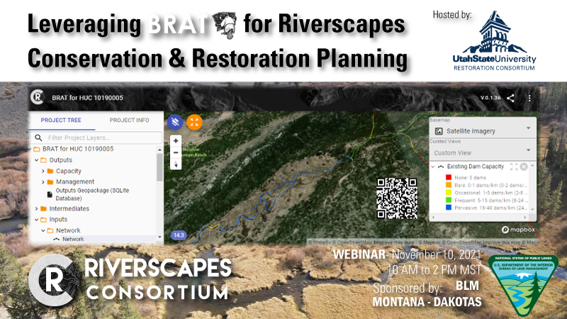
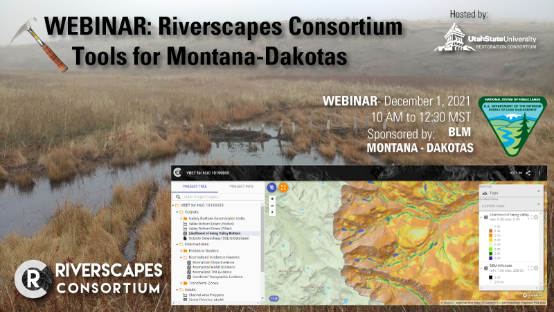
Leveraging Riverscapes Tools to Support Planning
Two webinars were sponsored by BLM Montana Dakotas, which covered some of the tools available an under development for Montana to support LTPBR.
The first covers how the BRAT, and how it can be used to help understand whether beaver dam actiivty might be an appropriate key process in your riverscapes and if so where associated risks may exist.
The second webinar is about the broader suite of tools under development for helping you understand your riverscapes across multiple scales.
Design in QRiS ( Riverscape Studio - QGIS Plugin -)
If you are interested, QRiS (in developement) is a plugin available for QGIS to facilitate doing LTPBR Design (and eventually Planning and Monitoring). A full version of the QRiS design is available for download (unzip and open QRiS using toolbar):
Pumpkin Creek Phase 1 Design (QRiS project)
Permitting
We cover permitting and the consultation process generically in Module 5, but it is helpful to see real examples. Here we provide drafts of specifically how the consultation and permitting process went for Pumpkin Creek.
NEPA Compliance
All projects led by federal agencies have to comply with the National Environmental Policy Act - NEPA. For those of you directly involved in permitting and particularly permitting on projects with Federal Land Management Agencies, the NEPA is a crucial hurdle your federal partners are having to show compliance with. Whether you realize it or not, they are either working under an existing determination or having to arrive at a new one. Determinations of environmental impact of proposed actions are made as part of an environmental review under NEPA can involve three different levels of analysis:
- Categorical Exclusion determination (CATEX)
- Environmental Assessment/Finding of No Significant Impact (EA/FONSI)
- Environmental Impact Statement (EIS)
CATEX is simple and has been common for LTPBR projects of small scale. If they go down the EA/FONSI or EIS route, you are talking a minimum of 1-2 year review and preparation period. The death sentence for project feasability is when this is engaged for every individual project. The alternative that some of our partners have pursued is to do larger, “programmatic” EAs that cover a broader body of work with greater geographic scope. Below are copies of the public comment versions of Alden Shalcross’s (BLM Montana-Dakotas State Aquatics and Riparian Lead), which was developed for Montana, North Dakota and South Dakota.
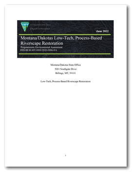 Montana/Dakotas Low-Tech, Process-Based Riverscape Restoration Programmatic Environmental Assessment
DOI-BLM-MT-0000-2020-0006-EA

Montana DNRC Joint Stream Permitting.
Joint applications (jointly submitted to State and USACE) can be found at Montana DNRC’s Stream Permitting pages. In states with a joint-application process (like Montana), one application package shown below can be prepared.
Army Corps Section 404 Compliance
In the Omaha District, which covers most of Montana, North Dakota and South Dakota draining to the Mississippi, we have seen some of the most cumbersome interpretation of permitting requirements under the Clean Water Act for LTPBR compared with other Districts (e.g. Sacramento, Walla Walla, Seattle, and Portland). Specifically, they have opted to require full, costly wetland delineations for each of these projects despite the existance of Montana Natural Heritage’s Wetland and Riparian Maps and the fact most of these projects seek to expand those wetlands, and most often not for mitigation purposes. This adds significant, unnecessary cost and time to the permitting process and is actively being negotiated with the Omaha District to reconsider its interpretation and stance.

On Pumpkin Creek, we were fortunate to have the expertise of Amy Chadwick who prepared the 310 Joint Application Form and Wetland Delineations.

Example of wetland delineation maps required by Army Corps.
Fish Monitoring
Niall Clancy (PhD Candiate University of Wyoming) is studying the impacts of LTPBR restoration in Prarie streams on native fish. He will share a short presentation Wednesday afternoon with us and will be helping us build (brining his own post pounder) on Thursday!

